The RCAAE has made a submission to the New South Wales Government in response to the Kosciusko National Park Draft Horse Management Plan. The RCAAE submission is available here.


The RCAAE has made a submission to the New South Wales Government in response to the Kosciusko National Park Draft Horse Management Plan. The RCAAE submission is available here.
Applications for PhD scholarships (via La Trobe University) are now available. If you are keen to study in the Australian Alps with one of our Researchers, then visit the University scholarship webpage for applications for any project, allocated on the basis of merit. These scholarships are available for domestic students only and should be developed with a prospective supervisor:
Research Training Program (RTP) Scholarship, Scholarships, La Trobe University
Applicants must be available to commence their degree between 1 February and 30 June 2022 on a La Trobe campus (note: advertising for the 2022 mid-year round will commence in March/April 2022.)
In addition, there are Dennis McDermott Scholarships also available:
Dennis McDermott Research Scholarship, Scholarships, La Trobe University
La Trobe University Research Equity Scholarships, Scholarships, La Trobe University
Please contact Assoc Prof John Morgan (J.Morgan@latrobe.edu.au) should you require further information on these opportunities. Please note: applicants from domestic students for PhD scholarships are due 31st October 2021.

by Iris Hickman, RCAAE summer student 2020/21
My interest into alpine ecology began at university, when one of the subjects I was taking at La Trobe University (BOT2PDE) delved into the factors influencing the distribution of alpine flora and the inter-relationship between species distributions and the environment. I found these interactions and the unique alpine communities it produced fascinating. However, I was shocked to learn that it was heavily threatened by climate change, anthropogenic activities, invasive species, and changes in fire regimes. Learning about the experiments that researchers conducted to investigate these threats in my lectures intrigued me, and I sort to learn more about the alps through the eyes of an ecologist. This led me to volunteer with RCAAE researchers in summer 2020 to learn about the work they conduct in the Victorian alps. There I assisted the 2019/2020 student, Nina Kerr. This fieldwork ended up being one of my most memorable volunteer experiences and ultimately led to me applying for the 2021 alpine studentship.
The 2021 studentship was adventure-packed right from the beginning and began with me taking on a seed dispersal project. This involved reconstructing seed traps from a previous researcher (Lauren Szmalko) and hiking them out to eight sites across the Bogong High Plains. I then monitored them regularly throughout the flowering season to collect data on how alpine wind dispersed plants disperse throughout the landscape. I became excellent at identifying wind-dispersed alpine seeds! I also assisted with monitoring rare and threatened flora, including the cute hemiparasite Euphrasia scabra, which very small population was severely affected by the 2019-2020 fires. I helped collected data on species range shifts, changes in phenology, soil surveys, fine-scale tundra patterns, among other things. Some of the data I helped collect contributed to one of the longest running ecology projects in Australia. I helped reconstruct these transects using hand drawn maps with landmarks instead of GPS points, it was like a treasure hunt!

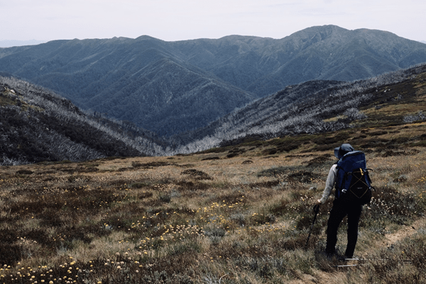
We hiked up several mountains to survey sites, including Victoria’s highest mountain Mount Bogong, and explored different systems, including snow-patches and significant wetlands. I met with other alpine researchers and liaised with Parks Victoria and the Falls Creek Environmental Officer. It was a great networking experience, and I really enjoyed the sense of community that we all shared working in the alps. I was also lucky enough to be able to do side trips to the Eastern Alps where we camped out in remote montane forests and woodlands in the Cobberas. On these trips I assisted in post-fire monitoring and horse damage assessments with Dr James Shannon for Parks Victoria. I experienced first-hand the devastating damage caused by pigs and horses. However, I was able to gain insight into what most of the Australia alpine region typically consists of, which includes the most beautiful Eucalypts with milky white bark, such as E. pauciflora, E. delegatensis and E. dalrympleana.


I also had time to myself to go camping and hiking to explore the walking trails of the Bogong High Plains. Fortunately, we experienced one of the best flowering years, due to the La Niña. The seas of Craspedia species were breath taking.. I was captivated by the beauty of the Australian alpine landscape, diversity of plants, the rarity and specialisation, and their ability to cope with extreme weather.


The experience with RCAAE gave me insight into what it was like as a researcher and led me to begin a mini-research project on the influences of elevation on the functional traits of high mountain shrubs. The studentship not only allowed me to deepen my knowledge in plant ecology, vegetation monitoring and field-based research but also allowed me to contribute to the conservation and long-term monitoring of one of Australia’s most vulnerable ecosystems. The experience was greatly influential on me, and I am grateful to have had this experience. Now, I am enrolled to complete my Honours in 2022 on a Mountain Summit Ecology project.


Mountain regions worldwide are the water-towers of the Earth. The Australian Alps produce over half of river flows in the Murray-Darling Basin which contain > 45% of Australia’s irrigated production (which is valued at more than $10B per annum). In addition, reliable winter snowfalls contribute >65% of the annual precipitation of the region, and the mountains host more than 2.5M visitors annually, with three quarters of tourists visiting the snowfields in winter, contributing roughly $960M annually in revenue for Victoria alone. Spring snowmelt into high country aqueducts and dams represents Australia’s largest energy store in the form of hydroelectricity. These local and regional economies can only exist because of a climate that produces regular snowfalls, and a mostly intact, adapted and resilient alpine environment. The alpine environment regulates water flows, controls soil erosion and provides habitat for many endangered and threatened plant and animal species. Indeed, the ecosystems of the Australian Alps are one of 11 Australian centres of plant diversity, one of 187 global biodiversity hotspots and they even include a RAMSAR listed site, Blue Lake, in Kosciuszko National Park. Alpine ecosystems – from bogs and fens to snowpatches – and some of their unique species (like Australia’s only hibernating alpine animal, the Mountain Pygmy Possum) rely on snow for protection from frosts and strong winds, for insulating soils, providing a steady water supply and as a cue for phenological events. Some species, like Snow Algae, even rely entirely on late melting snowpack as a habitat substrate.
It’s difficult to imagine the Australian Alps without snow. But predictable snowfalls and lasting snowpack are already dwindling, and a projected 30-70% decline in annual maximum snow depth relative to 1990 levels by 2050 (under a low-emissions scenario) seems likely. The ability of the Australian alpine environment to function properly without reliable snowcover and a lasting snowpack is unknown. Surprisingly, studies of snow ecology in Australia are few, and we do not have a good understanding of how, where or when snowpack interacts with vegetation or drives soil water content across the alpine landscape and, in turn, how this affects alpine plant growth in the months following snowmelt. But thankfully, that’s about to change.
Led by Dr Susanna Venn and Dr Adam Miller (Deakin University), with collaborators at the Australian National University, RMIT University and the Research Centre for Applied Alpine Ecology, La Trobe University, a new research project funded by the Australian Research Council and partners (alpine ski resorts, alpine nurseries, Parks Victoria and the Royal Botanic Gardens in Melbourne) will investigate how the Australian Alps will fare with declines in snowcover. Titled “Mountain champions: building resilience into alpine environments for a low-snow future”, the Research Group will assess whether alpine species have the regeneration and adaptive capacity to thrive under new climates, as well determining their tolerances to the extreme temperatures they will face in the future. The research also aims to determine which areas of the alpine landscape are most at-risk of collapse without snow. The project kicks off in 2021 (with post-graduate student and volunteer opportunities) and we look forward to working with our partners to help better understand “ice ecology” and to map a brighter future for our snow-covered ecosystems. Stay tuned for updates.

Zali Jestrimski, a La Trobe University Student, on her undergraduate research project investigating Dingoes in the Victorian High Country.
When Dr John Morgan suggested an undergrad research project on dingoes in the alps, I was thrilled. The idea was to use trail cameras at the Mt Hotham Alpine Resort – which had been set up to monitor foxes, cats and deer – to try and quantify the number of dingoes in the area. There was also the added bonus of assessing whether areas with dingoes had fewer feral animals. Dingoes have been a passion of mine for some time, and I know quite a lot about their behaviour from my time as a volunteer at a dingo sanctuary in Melbourne. But it was also apparent to me that we know relatively little about dingoes in the alps, and I was keen to improve that knowledge.

There is a misconception that there are no pure dingoes left in the Victorian high country. However, genetic studies prove otherwise and it was not surprising that the trail cameras at Mt Hotham have detected the species in the vicinity of the resort.
For my research project, I wanted to study the activity patterns of dingoes near Mt Hotham as there was nothing known about this. Where were they? When did they move about the landscape? In addition, studies elsewhere have shown that dingoes likely suppress cat and fox numbers, and may even affect the behaviour of Sambar deer. Could I observe fewer ferals where dingoes were present? While my study is a small one, and much more work needs to be done, I think I found some very interesting patterns.
In the vicinity of Mt Hotham, there were several dingoes observed over a two year period using the trail cameras to document their occupancy, including young ones. This suggests that dingoes are resident and breeding there. I found that there were less cats in locations with dingoes – although it’s hard to know if one is directly responsible for the other. I observed that dingoes do overlap with both foxes and deer but that the ferals tend to be active at different times to that of the dingoes. Are they avoiding the dingoes?
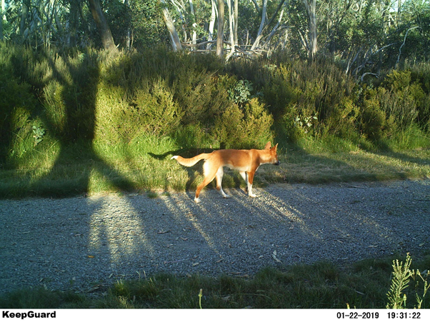
I hope this research is the start of an improved understanding of dingoes in the alps, as well as the role they play in this ecosystem. You can read about my work in The Victorian Naturalist 137: 96-104.
My Summer Studentship Experience, by Nina Kerr
I initially applied for the RCAAE summer studentship for the 2018/19 season. I was not successful that time around so instead, I used that summer to experience the Victorian Alps for my first time, by working for an environmental contractor eradicating Hawkweed (Pilosella sp.) near Falls Creek. One benefit of staring at the ground all day is that you quickly become familiar with the shapes, colours and distributions of different plants even without knowing all their names. I was blown away by the diversity of plants and keen to learn more about alpine ecosystems. The following season I reapplied and was excited to be accepted into the RCAAE studentship for the 2019/20 season.
Before going, I had mentally prepared for some things I would experience during the weeks ahead: learning lots of new plant names, the volatile weather, long days, data entry and working solo at times. Something which I had not foreseen was the widespread and devastating bushfire season of Summer 2019/20. Little of Australia escaped impact from these bushfires and we were no different. At the start of the season it was uncertain whether we would be able to go at all. Luckily, Falls Creek escaped any physical impact and I was able to spend 7 weeks there on and off. However, several active fires surrounded the region at times and the smoke haze was an eery reminder of the reality of the situation. Other subalpine alpine areas were not so fortunate, and we were able to witness the impacts of the fires at Mt Buffalo. Clearly fires are becoming more frequent in this region and it is a real challenge for those managing and protecting the natural assets of the park.
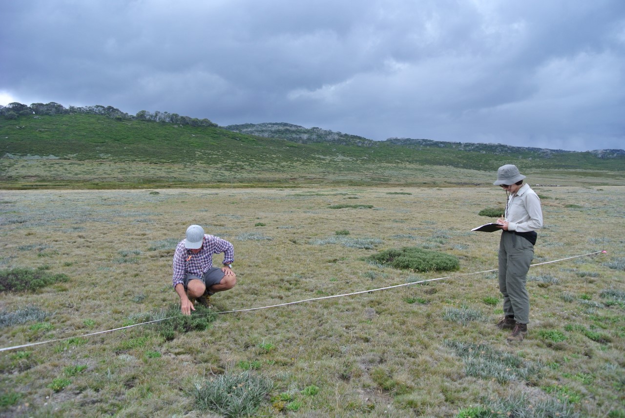
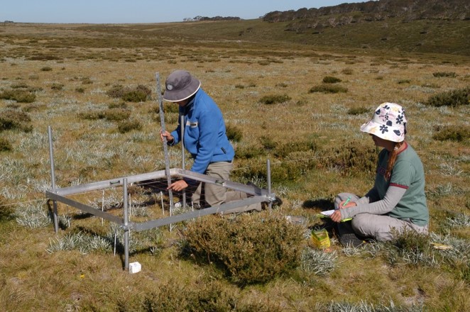
Re-surveying long-term plots in grasslands in Pretty Valley.
An experience I was humbled to be a part of was helping resurvey long-term ecological monitoring plots. This took us to some amazing subalpine and alpine grasslands and snow patches from Falls Creek to Mt Bogong. One survey took us to the Mt Fainter grassland, where the wind and rain were so strong over the saddle it threatened to rip the data sheets from my clip board. Thankfully, these transects were efficient to reconstruct as the pegs were still standing and the bearings to locate them were true. For the last couple of transects the rain stopped, a little sun came through the clouds and we got some spectacular views.

After completing some of these long-term monitoring plots, I gained a serious appreciation for simple and robust methodology that can be repeated over decades. Although the humble stake is a common friend among ecologists, I was still impressed to see the red gum pegs standing in snow patches after 40 years, as the seasonal snow-pack has the force to drag down-slope any object sticking too far out of the ground.
It was easy to feel inspired up in the Alps. I met so many different people including researchers, land managers and other students who shared an abundance of knowledge and an incredible passion for understanding and conserving this complex landscape. Experiencing the process of research has got me excited for post-grad research with honours and I know I will be able to apply many lessons and practical skills I gained last summer.
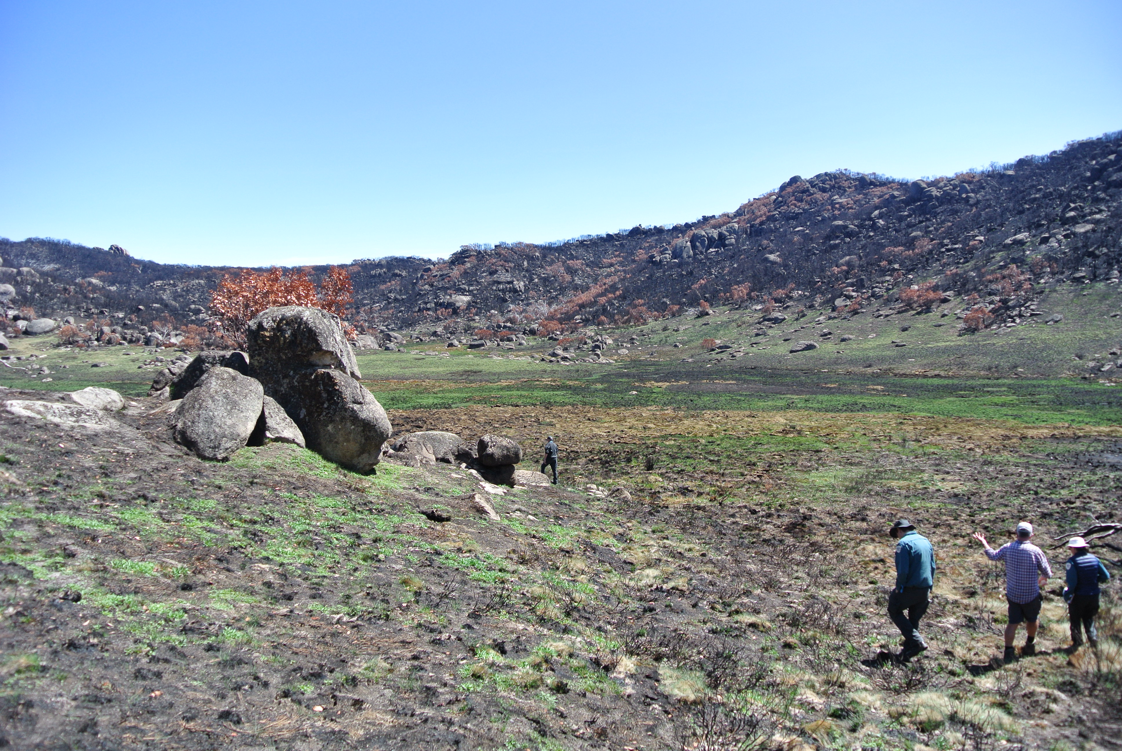
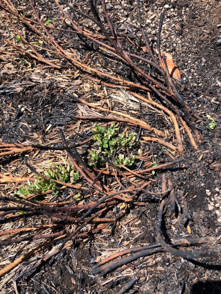
Burnt vegetation at Lyrebird Plain, Mount Buffalo
By Alex Blackburn-Smith, currently doing her honours with the Research Centre for Applied Alpine Ecology at La Trobe University
The Caltha introloba Herbland Community is one of the rarest and most specialised vegetation alliances in alpine Australia, yet we know very little about it. Indeed, for 40 years, no-one has been quite sure how to classify them. Are they associated with Sphgnum bogs? Snowpatches? Are they wetlands? The rarity of Caltha Herblands has been recognised enough to list them as a threatened communities under the Flora and Fauna Guarantee Act (1998), and they have further protection under the Environment Protection and Biodiversity Conservation Act (1999) through their association with Sphagnum Bogs (listed as endangered under EPBC) and Snowpatches (critically endangered under EPBC). Yet, while Caltha Herblands are a form of wetland, and while they do commonly occur in areas of late snow lie, and while they are typically surrounded by sphagnum or bog vegetation, Caltha Herblands are a separate vegetation unit. A base study of where they are and what’s in them is critical for their management.

Caltha Herbland in low cloud on Mt Nelse
So, what are they?
Caltha Herblands are semi-aquatic, sparsely vegetated, short alpine herb fields that occur on a rocky/gravelly substratum called a ‘pavement’. They rely on a constant water source, either a ground water source, such as a spring or ground seepage, or a water course such as a creek.
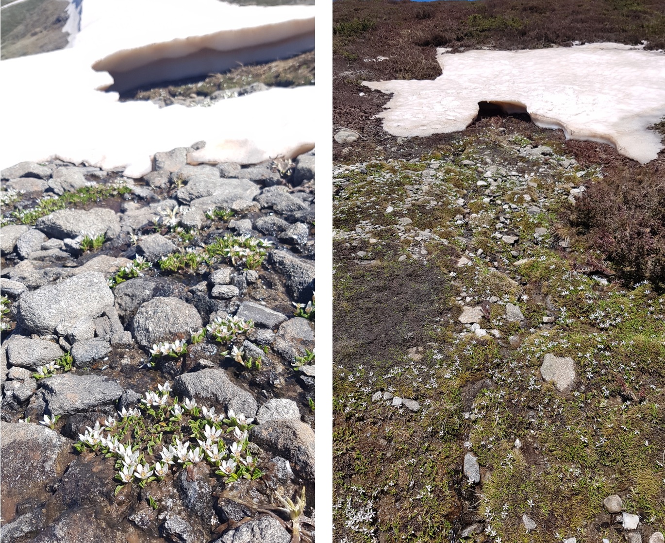
Alpine Marsh-marigold, Psychrophilia introloba (formerly Caltha introloba), in flower during snowmelt
Where are they?
Whilst restricted to the Bogong High Plains in Victoria, Caltha Herblands are found in a range of different landscape setting – from steep slopes under snowpatch vegetation, to relatively flat slopes beside creeks. At least 98 patches of Caltha Herbland community have been identified across the Bogong High Plains, from the northern to southern end, both above and below the tree line.

Caltha Herbland next to White Rocks Creek

Caltha Herbland surrounded by Sphagnum near Mt Cope
What’s in them?
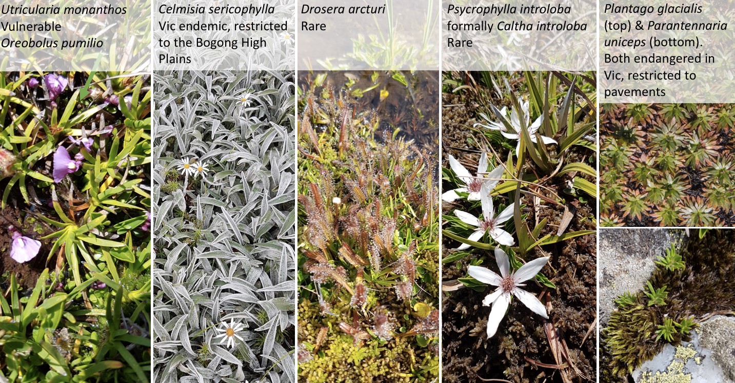
Some of the rarest alpine herbs and forbs in Australia! Key species include Psychrophila introloba (formally Caltha introloba – the species from which the community gets its name), Oreobolus pumilio, Drosera arcturi, Juncus antarticus and Celmisia sericophylla are the most common of the rare species across Caltha Herblands. Some sites contain species such as Oreomyrrhis pulvinifica, Plantago glacialis and Parantennaria uniceps which are all endangered species in Victoria and restricted to Caltha Herblands.
Why so important?
Not only do these communities contain a whole host of listed and vulnerable species, the total area that this community takes up within Victoria is thought to be less than 2 hectares. Further, we believe that the substrata on which this community lies is a periglacial relic or fossil periglacial feature. The origin of these pavements is hypothesised to be from freeze/thaw erosion and weathering action during a past cold climate period. If this hypothesis proves correct (further study is needed to attempt to determine this), then these communities have heritage significance as well as geological and geomorphological value.
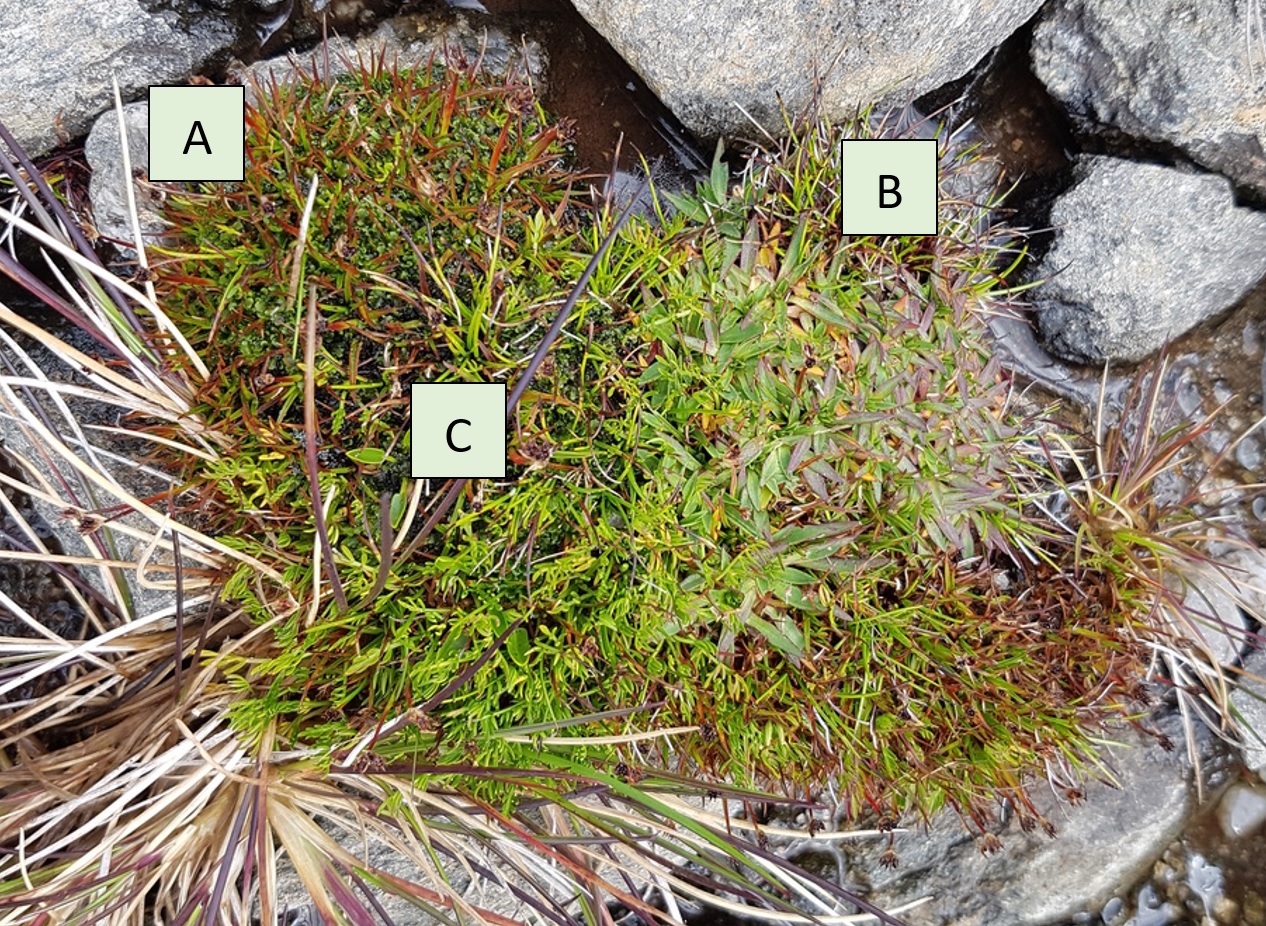
Cushion of (A) Juncus antarticus, (B) Plantago glacialis and (C) Oreomyrrhis pulvinifica growing on a pavement.
This study
I’m currently undertaking an Honours Research project that has three aims:
Currently, this study has finished the field work phase. Abiotic, including slope, aspect, size, degree of rockiness, soil depth and water cover, and floristic data has been collected from 19 sites across the Bogong High Plains. Eight of these sites have long-term data which will enable us to look at any broad vegetation change that has occurred over the past 40 years.

(Left) A typical floristic quadrat, (Right) Re-surveying in a long-term data site
We are sharing this post on about fire impacts on the high country treeline from the Mountain Journal. The original post can be found here.
Fires are still burning out of control across much of the Australian High Country. Yet we are already well into the blame game, where some people and groups are blaming environmental activists and/ or The Greens party for ‘stopping’ fuel reduction burning and hence making the fires worse. While this is not true, this resonates with certain anti green and conservative demographics (check here for an alternative view of the conversation).
There is no doubt that fuel reduction burning has a role to play in how we manage forests and other landscapes. The problem is that it is often seen as a ‘one size fits all’ tool that will reduce fire intensity in all environments. But in reality, it works well in some ecosystems and is counter productive in others. This is a subtlety that is lost on the ‘fuel reduction is the answer’ boosters.
The argument that we need to increase fuel reduction burns in snow gum and true alpine environments is already caught up in the broader land management debate, and will continue in the coming months. So it’s worth taking a good look at what science says about the value of fuel reduction in our high mountain areas.
Snow gums are the quintessential alpine tree of the mainland, generally growing at elevations between 1,300 and 1,800 metres asl. Wildfire has devastated large swathes of snow gum habitat in the last few decades, with significant fires in the Victorian High Country in 1998, 2002/3, 2006/7 and 2013. Over 90% of the Victorian distribution of snow gums has been burned at least once since 2003. Each of the large fires of the last 15 years has overlapped to some extent, leaving thousands of hectares of snow gums burned by wildfire twice, and sometimes three times.
Much of Kosciuszko National Park was burnt in 2003.

Fire at Precipice Plain, VIC Alps, Jan 2020
Early European occupation of the mountains was based on the widespread use of fire to clear land. This broad acre approach to burning was at odds with First Nations careful, localised use of fire. As noted by Philip Zylstra (Centre for Sustainable Ecosystem Solutions, University of Wollongong):
‘British graziers … cleared country using fire. The Snowgums tell the story: a seven-fold increase in fire scars when the invasion came’.
This use of fire has continued today, but does it reduce the flammability of the mountains? Philip points out that fuel reduction only brings a short reprieve:
‘Recently, I looked at every fire mapped across these mountains for nearly 60 years, and I found one thing in common from the foothills to the peaks: fire has always followed fire. For a couple of years, it brought quiet, then the undergrowth made the forests up to eight times more likely to re-burn for the next couple of decades until it self-thinned. So why did anyone burn it if this was the result?’
One significant piece of research that should inform our understanding about fire on snow gum forests looked at the impacts of fires on Lake Mountain and the Buffalo Plateau. The report How snow gum forests and sub-alpine peatlands recover after fire was written by Fiona Coates, Philip Cullen, Heidi Zimmer, James Shannon. They used the long unburnt Baw Baw Plateau as an example of what these systems could be like in the absence of fire events.
They found that:
Fires impact on mature trees and the resulting growth of seedlings may mean that snow gums start to colonise adjacent alpine vegetation.
David Turner, in his research carried out for his Masters of Environment thesis (School of BioSciences, University of Melbourne) titled Treeline physiognomy following wildfire in the Victorian Alps, Australia investigated snow gum seedling establishment above the treeline after fire.
He found that new seedling growth was greater after fire compared to locations long absent of fire. ‘Model probabilities estimate a 22% chance of seedling establishment four metres above treelines that are burnt, compared to only a 1% chance in unburnt locations’. (He does note that the number of seedlings, which was modelled to increase after fire, is controlled by the amount of litter and competition found at the site. Low levels of litter and competition facilitate maximum seedling growth).
One significant outcome regarding frequent burning showed that optimal tree ages that influence seedling establishment were found to be between 24 and 42 years of age. If climate change subsequently reduces fire frequencies to less than (for example) every 20 years, then seedling numbers may actually fall.
Repeat burn times that outpace snow gums (Eucalyptus pauciflora) reaching their optimal reproductive maturity age may subsequently have dramatic effects on the Victorian treeline.
His research suggests that the Victorian treeline physiognomy has slightly changed due to the 2003 alpine fires.
Sadly, the fact is that climate change is making fire seasons worse. As noted by the Victorian government’s report ‘Climate Science Report 2019’,
‘There has been an increase in dangerous fire weather and the length of the fire season across southern Australia since the 1950s. Fire weather in Victoria is largely measured using the Forest Fire Danger Index (FFDI). This index estimates the fire danger on a given day based on observations of temperature, humidity, wind speed and fuel (based on factors including recent temperature and rainfall). Although considerable year-to-year variability also occurs, there is a trend in more recent decades towards a greater number of very high fire danger days in spring’.
So, regardless of how we manage forests with regards to fuel reduction treatment, we will be facing worse and longer fire seasons. It would appear that one key strategy will be to keep fire out of snow gum woodlands wherever possible, so these systems can age and become less fire prone.
Regular and repeated fires kill snowgums. So if we want to see snow gum forests continue we need less fire, not more, even low intensity fuel reduction burns. According to research by Tom Fairman, Associate Professor Lauren Bennett and Dr Craig Nitschke, of the University of Melbourne:
‘We found that the lignotuber continued to re-sprout very well after one fire, but after two and three fires, the number of new sprouts significantly declined. The level of whole-tree death (that is, the stems and lignotuber dying) was fairly low following one and even two, fires; however, after three successive fires, on average half of all trees in our plots were dead. In some plots, this figure was as high as 80 per cent of all trees’. (source).
A study in the journal Austral Ecology provides the most comprehensive analysis ever performed of the fire history of forests in the Australian Alps. This is a significant piece of work because it says that unburnt forests are less fire prone than those that have been recently burnt.
This has implications for how we manage these forests and woodlands. The current widely held assumption is that by reducing fuel loads, fire reduces the flammability of most eucalypt-based forests.
The study, by Dr. Philip Zylstra of the University of Wollongong (and available here) says:
‘The study provides an evidence base for fire management in the Alps that is based on observed reality rather than theoretical concepts.
‘Throughout the period for which fires have been consistently mapped across the Australian Alps National Parks, they have been smaller and less severe in long unburnt forests’. This is consistent across the five broad forest formations that cover the Alps’ (these forest types are Tall Wet Forest, Open Forest, Subalpine Forest and Woodland, Dry Open Forest and Low, Dry Open Forest).
The study looked at fires in five key forest types in the Alps and assessed how fire frequency changed over time. To take the example of snow gum woodlands, after a fire passes through, they are unlikely to burn for 6 years after fire, then more flammable until 25 years old. However, ‘forests older than this are 2.3 times less likely to burn than younger forest’. A similar pattern can be observed in the other forest and woodland types.
Ben Keaney, in his PhD research titled Bogong Moth Aestivation Sites as an Archive for Understanding the Floral, Faunal and Indigenous History of the Northern Australian Alps noted that climate change is already impacting on the mountains, and could drive forests into a more scrubby, flammable form, and that this has implications for land management practises like fuel reduction burning:
‘Structural change of the vegetation due to human induced climate change is a real threat to sub-alpine ecology. Pryor (1939) described the possible extent of high country degradation from burning as two extremes, that is a slightly damaged forest that is more or less undisturbed, to a barren waste of eroded mountains with a sparse cover of plants. This is poignant as a prediction for the natural land managers under the effects of anthropogenic climate change, where the flammability of the forest can drive ecological change of vegetation away from a forest form into a scrub form, a point that should be taken to account in the prescription of fuel reduction burns. Predictions of the effect of climate change on the ACT include fires with higher intensities, with reduced inter- fire intervals and that are more prone to spread (Cary, 2002)’.
The take home message seems to be that if we can reduce the frequency of fire at a landscape level in these ecosystems through the juvenile ‘danger’ period when there is a lot of vigorous re-growth, they become less fire prone after a period of 14 to 28 years (depending on the forest type). This means that older forests should be left alone rather than burnt to reduce fuel load, and younger forests should be encouraged to mature rather than being treated with fire to keep them permanently in a juvenile/ more flammable stage in their growth.

This forest (Mountain Gum?) near Lost Plain had a light fire through it in 2019. It cleared out the understory and moved into the canopy in some areas
What are the implications for fire fighting in the alpine country? The key message is that we need to keep fire out wherever possible. Locking in more intense fuel reduction regimes are unlikely to make snow gum forests less fire prone, for the reasons outlined above.
1/ More fire fighting resources. Most fires in the Alps start as a result of lightning strikes – that is they start small at a specific point. The aim must be to hit these fires while they are small.
This requires additional fire fighting resources at the state level to tackle these fires as soon as possible, before they grow and become difficult to contain. DELWP and Parks Victoria firefighters are well trained and equiped to fight these fires and do a great job of tackling them. But we clearly need more firefighters.
As one example of how the system gets overwhelmed: on New Years Eve 2019/20 a lightning storm passed over the Victorian Alps, starting many fires. DELWP and PV crews quickly mobilised to put these fires out before they grew, but some more remote fires were not able to be contained and subsequently grew into large blazes (such as the fire at Mt Tabletop near Mt Hotham, which eventually joined with other fires started by lightning and is now more than 42,000 hectares in size).
Stay governments should consider increasing the number of remote area fire fighters for the next fire season.
2/ Minimise burning for asset protection. There are various human settlements in alpine areas, which need to be protected from fire, especially the ski resorts. Doing fuel reduction burning is sometimes used as a last resort before fire fronts hit. The longer term implications of this need to be considered. Fire breaks are widely used in the Alps to limit the movement of fire. Research should be carried out to determine the relative value of fuel reduction, use of fire breaks, and other asset protection work around human settlements.
3/ Consider the development of a volunteer remote area fire fighting force. The Country Fire Authority (CFA) and Rural Fire Service (RFS) do a remarkable job of protecting land and community from fire. While they are primarily responsible for fires on private land, they are often active in fighting fires on public land. But their equipment (trucks) is often too heavy for deployment to remote areas with rough tracks and they are not directly trained or resourced to work in remote areas.
Is it time to develop a new fire fighting force that is specialised in remote area fire fighting? It could be part of RFS/ CFA or be a new stand alone entity, and would work closely with public land firefighters who are already doing this work. They could be trained in the same way that PV and DELWP prepare their rappel and hover exit crews (specialist firefighting roles performed in remote locations).
There has previously been a similar group in Tasmania, called the Smoke Walkers. The Smoke Walkers were volunteers, mostly bushwalkers, who were deployed to remote areas in Tasmania’s World Heritage Areas in instances where lightning had started fires that had not yet turned into major blazes.
In light of the scale of this summer’s fires, this is an idea that needs consideration in NSW and Victoria. A proposal can be found here.
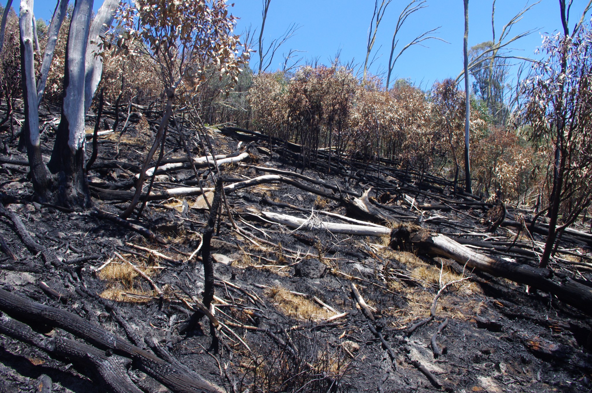
Bushfire in the Victorian Alps
The 2019/20 Black Summer Bushfires, where significant fires were burning in northern and southern NSW, eastern Victoria, South Australia and Western Australia at the same time, has stretched the nation’s resources and capability to respond to such events. A clue to the reason for the extensive fires can be found in the data recorded by the Bureau of Meteorology. Much of eastern Australia in 2019 was:
In Victoria, >1.5M ha of land was burnt, mostly in the east of the State, with profound impacts on many native animals, plants and landscapes. Some fires did affect alpine areas, including at Mt Buffalo National Park and the Alpine National Park. The extent of fires (at January 2020) is shown below (in red). Importantly, it is obvious that fires have been frequent, extensive and – in some places – repeated since 2003. It is the frequency of fire (what ecologists call the ‘fire return interval’) that will dictate the likelihood of ecosystem recovery. Looking closely at the map, you can see some high mountain areas have been burnt in 2003 and 2020, while others have been burnt in 2013 and 2020, and others near Hotham Heights have been burnt in 2003, 2013 and 2019.

Fire history map for the Victorian High Country, produced by Thomas Fairman.
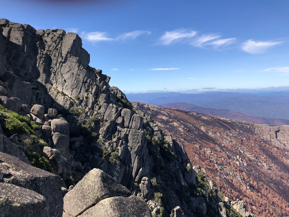
Here’s a selection of photos that document the type of burning that has occurred in the Victorian Alps. The RCAAE will be monitoring the recovery of alpine ecosystems – utilising it’s network of long-term plots – to determine the ecological resilience of these areas.

Burnt heathland and grassland, north of The Horn, Mt Buffalo

Alpine heathland, grassland and wetland dominated by Sphagnum cristatum has been burnt at Mt Buffalo, south of The Horn
Forested slopes have been burnt, south of The Horn, Mt Buffalo

Obligate-seeding shrubs – like Grevillea australis – are killed by fire
Hovea is a resprouting shrub, recovering from basal buds, Mt Buffalo

Not all tussock grasses resprout well after fire. Here, Poa clivicola in an alpine grassland at Buckety Plain appears to have died when the canopy is consumed.
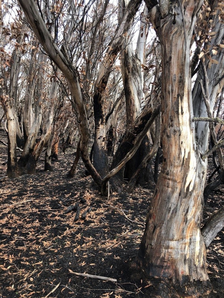
Snowgum forests near Mt Cope have had their heathy understorey consumed by fire. Note the leaves of the trees have been scorched by the heat of fire rather than consumed by fire.
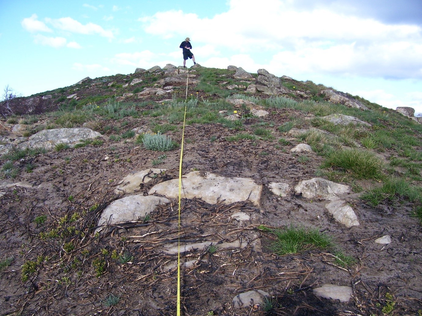
Scientific research in the Australian Alps has a long and rich tradition. In 1945, Maisie Carr (nee Fawcett) and Professor John Turner (from the University of Melbourne) established the first long-term monitoring plots in the Victoria Alps at Rocky Valley and Pretty Valley on the Bogong High Plains.
‘Rocky Valley’ is a 5-ha exclosure that was the first permanent plot to be established by Maisie. In January 1945, she selected a large area (a small catchment) on the upper slopes of Rocky Valley that contained a range of vegetation types—mossbed, snowgrass grassland, open heath, closed heath and a Carex-dominated late lying snowbank. A fence was erected to exclude cattle, and a range of permanent plots established to monitor vegetation recovery inside the fence.
‘Pretty Valley’ is a 0.4-ha exclosure (and adjoining control on the edge of the Pretty Valley catchment) that examined the impacts of cattle grazing on range condition in Poa-dominated grasslands. The State Electricity Commission of Victoria erected the fence in 1946 (using the local snow gums for fenceposts) and permanent transects were established. Point quadrats used to assess changes in vegetation composition, ground cover condition, and bare ground.

Both plots have been maintained to the present day and are now an integral component of the La Trobe University led Research Centre for Applied Alpine Ecology’s long-term plot monitoring network. Building on Carr and Turner’s work, RCAAE alpine ecologists have expanded the number of sites over the decades to include the wider Victorian Alps. An ongoing surveillance regime examines the impacts of bushfire, introduced ungulates such as sambar deer, exotic plant invasions and climate change on rare species persistence, plant community dynamics, and landscape function. With a succession of alpine scientists working on an expanding network of permanent plots (today there are more than 50), the value of the RCAAE Plot Network for documenting environmental change is inestimable.
To curate the long-term data, a purpose-designed database was commissioned. With the assistance of La Trobe University’s Department of Computer Science and (partly) funded by the Terrestrial Ecosystems Research Network (TERN; 2012-2017), the database has become the premier repository for long-term scientific data from the Victorian Alps. Over 70 yrs of monitoring at Maisie’s Plots have been captured in the database, providing a record of the sites’ vegetation change, represented by an exceptionally diverse set of population-related observations totalling over 200,000 records. More than 35 yrs of (near) annual population monitoring of the threatened Mountain Pygmy Possum has been entered into the database, along with data on roadside weed invasions, shrub dynamics in open heathlands spanning multiple decades, snowpatch vegetation change since 1992, and microclimate records (including soil and air temperature) since 2003.

These exceptional data provide an invaluable source of information. “The RCAAE database allows scientists to answer questions about long-term alpine ecosystem dynamics and their vulnerability to changing patterns of climate, fire and land-use pressure,” says Dr John Morgan, member of La Trobe University’s Research Centre for Applied Alpine Ecology. “Getting data into a database is a fantastic achievement, and one that needs ongoing support.”
Long-term research also needs to be supported to provide an evidence base for management decisions. The type of detailed monitoring undertaken in the Victorian Alps allows the RCAAE to anticipate environmental change and to inform how best to manage the land for sustainable use. According to Dr Dick Williams of Charles Darwin University, and an inaugural RCAAE member, the understanding gained from this research has also highlighted its current limitations. “70 years is a short time in the Alps, and there are still many things we don’t understand. Long-term monitoring will always be vital for increasing our understanding, anticipating change and managing the alpine environment for sustainability.”
The value of long-term research is often under-recognised. But sometimes being present in a landscape and taking repeat measures through time is the most innovative and important thing one can do to understand that landscape, how it is changing, and how it is likely to change in the future. The Australian Alps – small and vulnerable as they are to climate change and exotic invasions – are among Australia’s best monitored ecosystems, and it is from this evidence that trends, trajectories and change can be placed into context. Maisie Carr and John Turner could never have imagined such an enduring outcome of their work when the first fence-post was sunk at Rocky Valley in 1945.
For more information on the Victorian Long-term Alpine Plots, please contact Dr John Morgan at alpine.ecology@latrobe.edu.au
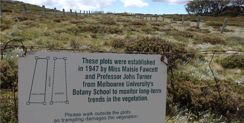
Fig 4. Still going strong. Maisie’s ‘Pretty Valley’ plots are due to be monitored again in 2023. Documenting the ongoing changes in the vegetation inform managers about successional dynamics in alpine rangelands, ongoing effects of drought, as well as providing a means for the early detection of new invasive plant species.
